|
|
, Chiang Rai Province") |
Day 12 - Monday 26 December 2016 Honour at Honey........With a full day in prospect in and around Chiang Saen we need to spend a third night in the town and there’s a consensus that Honey Hotel deserves the honour again. It’s an earlier breakfast at 9am and we settle up before heading out. Sob Ruak (Golden Triangle)........Inevitably the Golden Triangle has to be included sooner or later and we head there first. 15 minutes later we pass the border crossing point which is a river crossing here then luckily find a parking space right opposite the park overlooking the iconic Golden Triangle, the junction of three countries; Thailand, Myanmar and Laos. Laos is divided from Thailand by the mighty Mekong River here, while one of its tributaries, the Ruak River, divides Myanmar from Thailand. Inevitably it’s a major tourist attraction simply because of the view. Like many sights in the north, I’ve been here before but it’s still a privilege to record it for my website. At the end of the day a view is a view and there’s no need to spend more than half a hour here unless you wish to take a boat trip. Obviously there is a premium for anything you buy here. But I’m not heading back to Chiang Saen just yet.
Wat Phra That Pu Khao........Wat Phra That Pu Khao is located on a hill above Sob Ruak and offers outstanding views of the Golden Triangle. This temple consists of a viharn at the back of which is a mondrop (shrine of the Buddha) surrounded by 3 satellite chedis. The temple has a double boundary wall with porches and staircases on three sides. According to legend Chao Kaeo Ma Muang had this temple constructed in 759 but the temple ruin that you see was probably constructed in the 14th Century.
Wat Sam Mum Muang........Wat Sam Mum Muang lies of a separate hill along a road that connects with Wat Phra That Pu Khao but which is difficult for some vehicles. Minivans for instance won’t use it. Yet reaching this temple affords even greater views across the Triangle. The temple itself has a moat but there is no provenance for its construction. Between 2005 and 2006 the temple was excavated but only a few motive tablets were found.
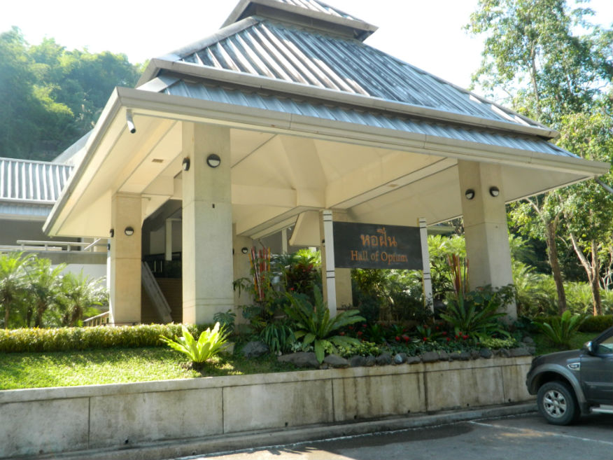
Hall of Opium........photo. The Hall of Opium (right)lays just a couple of kilometers along Highway 1290 towards Mai Sai. This project, known as the Doi Tung Project, was initiated by HRH the Princess Mother in 1988 through her desire to educate people about the background to opium production and instigate alternatives to provide a sustainable income and reduce the opium problem. As I am not able to carry out a review of the Hall of Opium I refer you to the Doi Tung Tourism website, http://www.doitung.org/tourism. A related site is Doi Tung Royal Villa. Entry is 200 baht, 150 baht for Thais Google Map.
Believing I don’t have enough time to review the Hall of Opium, I head back to Chiang Saen following the river south, where there is still a lot to do. Wat Mongkol........Wat Mongkol is located to the northeast of Chiang Saen City. It was excavated between 2005 and 2006 by the Fine Arts Department. The evidence suggests the temple was built in two stages. The first construction was the viharn, chedi and mondrop. Later a larger ubosot was connected with the chedi. The building style suggested it was constructed in the golden age, 16th Century. Northern City Wall........The Northern City Wall measures 950 metres in length. Archaeological investigations between 2000 and 2001 indicate that this wall was built during the second phase of construction of the city. While the outer side is vertical the inside wall is stepped consisting of between seven and nine terraces with ramparts at the top. This is a serious a attempt at city defence as it would enable rapid troop deployment and restrict erosion at the same time.
Wat Sangkha Kaeo Don Tan........Still heading along the river bank we stop for lunch but the service is slow when we really need to press on. To save time while waiting I log the next site a short distance away, Wat Sangkha Kaeo Don Tan. The Yonak chronicle records that this temple was founded in 639. Chronicle 61 mentions that the temple lies close to Wat Pha Khao Pan. The temple is currently a ruin consisting of a chedi and a viharn facing east. The second structure is the ordination hall. An engraved figure on a brick depicting a scene from the Maha Vessantara Jataka, the last life before the enlightenment of the Buddha was found here. Construction was probably 16th Century.
Wat Ban Rong Wat........Ban Rong is situated to the southeast of the city close to the River Khong. The site consists of four buildings, a viharn with attached room and three chedis. No precise date is known for its construction but comparison with similar temples in the area suggest it was constructed in the 15th Century but abandoned when Burmese troops entered the city, late 16th Century.
Old Chiang Sean City and Mekong River
Wat Muen Chiang........Legend has it that Wat Muen Chiang was built by the ruler of Chiang Saen in 1488 for enshrining relics. The brick chamber-style chedi stands high on a high rebated base with torus moulding. The relic chamber is adorned with stucco reliefs. In front of the chedi is a viharn facing east. This chedi is similar to the one at Wat Phra That Chomkitti. Din-kor Gate Fort........The Din-kor Gate was the southern entrance to the city. It was build in a horse-shoe shape with a moat It was 2.5 metres high and 57 metres long, substantial defensive workings.
Wat Song Pee Nong........This temple lies near the road 1290, some 5 kilometres south of Chiang Saen. Legend relates that Wat Song Pee Nong was a holding camp for the King of Saen Pu while he was surveying for the site of a new city. The site has chedis, a viharn, a stupa and sala. The chedi is in Lanna style, 14th-15th Century with a bell-shaped replacement.
Wat That Khong........The temples to the south of the city lie in an area known as Chiang Saen Noi (Wieng Preuksa) which predates the city of Chiang Saen. Wat That Khong has a chamber or image room on a square base which is of Lanna style, 15th Century. The viharn is incomplete thought to be because of road construction. Highway 1290 runs past this site. Pottery from the Lanna Kilns have been found here. Wat That Khieo........Wat That Khieo can be seen to the right of the highway (1290) heading south past Wat Song Pee Nong. This temple consists of a bell-shaped chedi and an east-facing viharn. On a pedestal with stucco decoration sits a lime Buddha image now in ruin while surrounding these are minor monuments. This temple is thought to be 17th Century during Burmese occupation.
Wat Phra That Pha Ngao........Wat Phra That Pha Ngao is an ancient, and sacred temple located south of the city gate. The legend has it that those who become ill, and come to worship here at this temple, will be cured. Wat Phra That Pha Ngao is built in Lanna architectural style and is was well-preserved. The name ‘Pha Ngao’ (or shading rock) comes from the large, gigantic stone where the chedi is located. People named it ‘Pha Ngao.’ In early times, in the Yonok Nakhon period, Wat Phra That Pha Ngao used to celebrate its glory. However it became deserted and overgrown. Pha Ngao cave where the temple was located was shut for a long period of time but on reclaiming the land an ancient Buddha image, Luang Por Pha Ngao, sculpted in Sukhothai style was found now enshrined on a large brick base. The temple now has a beautiful Ubosot, decorated with delicately carved wood in Lanna style depicting biography of the Lord Buddha.
Phra Borommathat Putta Nimit Chedi........Above Wat Phra That Pha Ngao on the hilltop, three ancient stupas in ruin were discovered. Subsequently, Phra Borommathat Putta Nimit Chedi was built to cover the old ones. From this temple on a hilltop, there are arguably the best views of the Mekong River and the foothills and mountains of Laos beyond. As if it were a grand finale I wait ages for Katoon who has disappeared into the chedi. When I go searching she is talking with a monk having asked for a blessing. The monk explains that the blessing is for me to be in good health. I play it down as usual but the monk has a curious outlook on life. When I study the history of civilisation in any context, I find the construction of temples is central to each one. Yet the monk claims it is all unnecessary and further claims that what is written by scholars is incorrect; just legend. In which case I have wasted my time and effort with what you read here right?
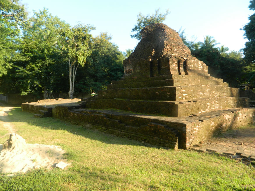
Pile of bricks........photo. so it’s around to 7Eleven within walking distance for something warm. Coffee is however free in Surprisingly it’s not yet 4pm but the material collected today for this website is substantial. As always there’s never enough time to cover everything and a line has to be drawn somewhere. I head back to Honey Hotel to take a break and get an early dinner. Yet there is one final mystery I’d like to solve and that relates to the pile of bricks in the back yard. I take a wander round but I see no signboard. The temple has a base for a viharn with the ruin of a pedestal for the Buddha facing east across the river. To the rear is a chedi and evidence of other structures nearby. I ask the receptionist about it and it seems this temple is unrecorded and no excavations made. This is likely due to it being boxed in with urban development: The temple effectively doesn’t exist. Presumably if it had appeared on any map then planning permission for Honey Hotel may not have been granted. Hmmmm! Declaration........I can now declare that unless I can find an hour in the morning there will be no more ancient site visits on this tour. There’s a lot of writing to do this evening. Before that we head out to a restaurant recommended to Katoon. We didn’t have a dinner as such yesterday but I feel she’s well made up for it now. While I enjoyed the river fish, I wasn’t that enthusiastic about the other dishes she ordered. Back at the room I’m still writing at 10.30pm but tomorrow the long journey back to Bangkok will begin. Next Page. |