|
Khánh Hòa Province
Khánh Hòa is a province of Vietnam located in the South Central Coast. It has a population of 1,066,300 and spans an area of 5,197 km² and its capital is Nha Trang. Khánh Hòa is the site of Bảo Đại's summer home, the Pasteur Institute of Nha Trang, the Institute of Oceanography, the Institute of Vaccines and Biological Substances, and was headquarters of the US Army's Special Forces ("the Green Berets") during the Vietnam War in the late 1950s and 1960s. Cam Ranh Bay port is a deep sea facility at the sourthern end of the province, the best site for submarine bases in Vietnam. There is an ancient Hindu temple from the Champa Era on the north side of Nha Trang.
Geography......The provincial coastline spreads from Đại Lãnh Commune to the end of Cam Ranh Bay with a total length of coastline of 385 km featuring numerous creek mouths, lagoons, river mouths, and hundreds of islands and islets. The province also administers large territorial waters including the Spratly Islands. The coastline is indented by several bays, most notably the four bays Vân Phong Bay, Nha Phu Bay, Nha Trang Bay (Cù Huân) and Cam Ranh Bay, of which Cam Ranh Bay with its area of around 200 km², encompassed by a mountain range, is regarded as one of three best natural seaports in the world. Cam Ranh Bay is strategically important and has been used as a naval base by several major powers throughout history.
The province is mostly mountainous. The highest peak is Vong Phu Mountain (2051m) at the border to Đắk Lắk Province. The only large lowland area is located around Ninh Hòa town in the north of the province so not much land is available for agriculture. 87,100ha or 16.7% of Khánh Hòa's total area are used for farming, one of the lowest shares in the South Central Coast. Forests cover more than half of the province's area. The province enjoys a mild climate with an average annual temperature of 26.7°C. There are two distinct seasons: the rainy season lasts from April to December, with the other months being the dry season.
History......The site of what is now Khánh Hòa had been within the territory of the Champa Kingdom before it was annexed to Đại Việt's (Viet Nam's) territory. In 1653, one of the Nguyễn lords, Nguyễn Phúc Tần, sent his troops to occupy Phan Rang. The Champa king Bà Tấm surrendered to Nguyen's troops and ceded an area from the east of the Phan Rang River to Phú Yên to the Nguyễn lord.
In 1832, under the rule of emperor Minh Mạng, this area was renamed Khánh Hòa. Under French Indochina, the provincial capital was located in Diên Khánh Citadel, but it was relocated in Nha Trang Town in 1945.
During the Vietnam War, Khánh Hòa was a hub of military activity for the Republic of Vietnam army (ARVN), navy and airforce and for the U.S. Pacific Air Forces (USAF), particularly in Cam Ranh Bay and at the Nha Trang Air Base. The II Corp. headquarters was located in Nha Trang populated with general and field officers, intelligence groups and ARVN liaisons.
In 1977 under the communist regime, Nha Trang Town was upgraded to city status. In 1982, the National Assembly decided to incorporate the Spratly Islands into Phú Khánh Province. On June 30, 1989 Khánh Hòa Province was split from Phú Khánh Province having been part of Phú Khánh Province since the fall of Saigon in 1975.
Tourism......The province is still largely off the radar as far as international tourism is concerned but with welcoming beaches, affordable prices and a facinating history there is no reason to ignore it. The main attractions are: Raglai House, Diên Khánh Citadel, Po Nagar Tower, Amboyna Cay and the Nha Trang Coastline.
|
Khánh Hòa Province
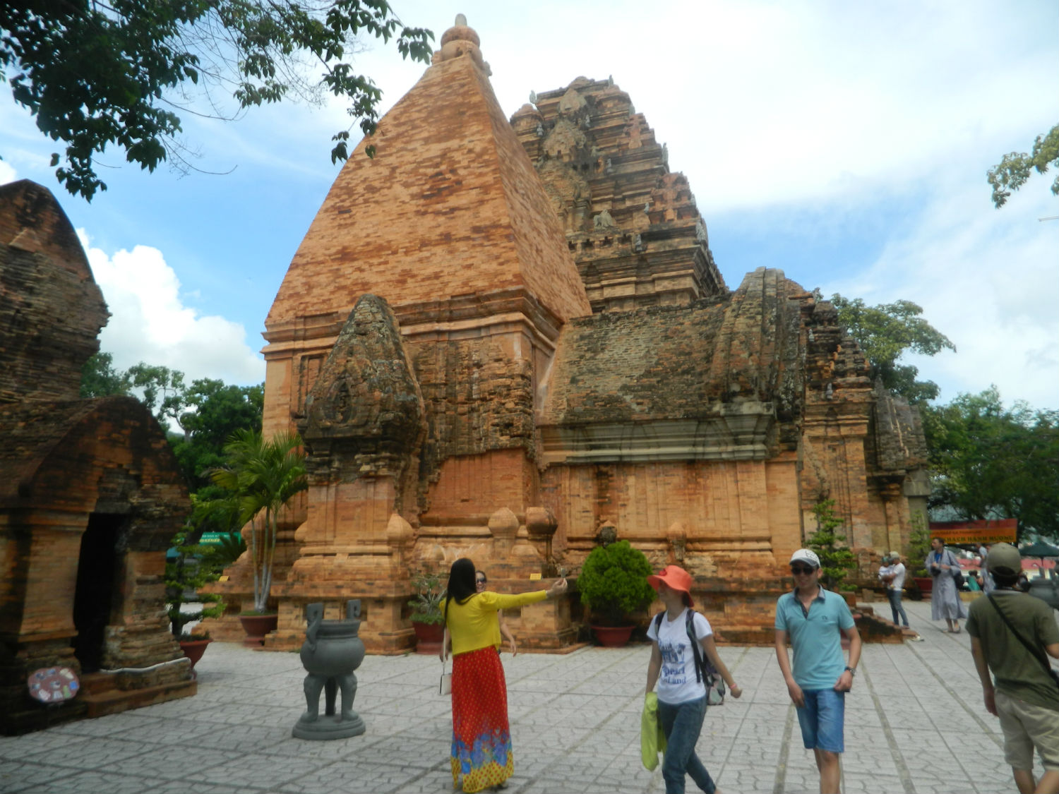 Thap Ba Ponagar, Nha Trang
|
